
aGIS - Accurate Geographic Information System
We are fundamentally changing the way we process, store and produce our data. aGIS are site plans of large areas based on multiple data sets. Here is an example of a plan in the Little Beach Area.
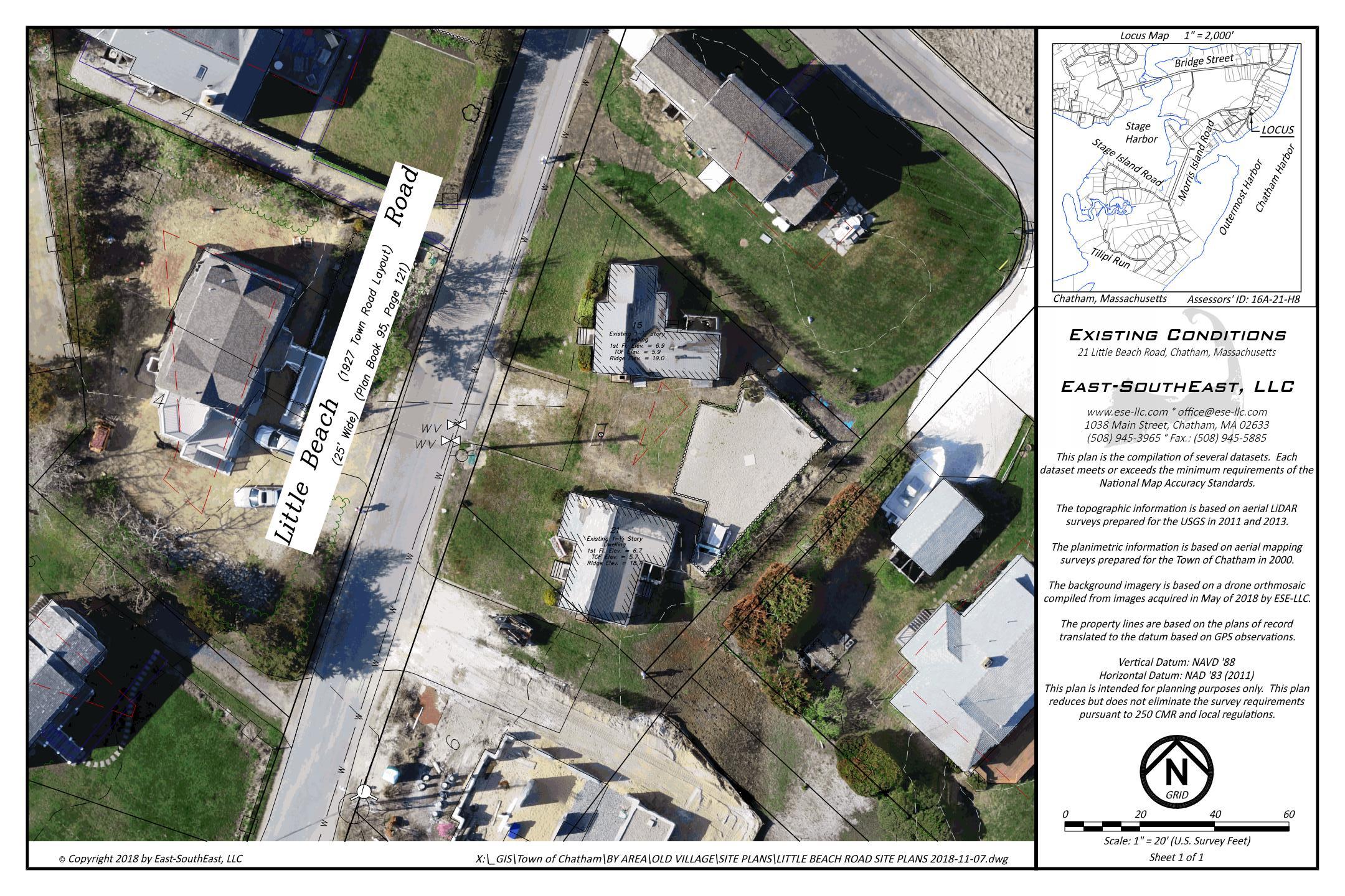
Just like the GIS plans available from the town, this plan is intended for planning purposes. The difference is the data is substantially closer than the data on the GIS maps from the Towns.
Use these maps responsibly. The data does require verification by a surveyor before it can be sealed by the surveyor. This may or may not require additional field work.
The plan includes the following groups of data:
- Boundary – The property lines and easement line depicted are based on the plans of record put into place with traverse and GPS measurements. To meet 250 CMR, additional research is required to determine the correct plan was used and incorporate any easement not depicted on the record plans.
- Image – A recent drone orthophotograph is in the background on a layer than can be frozen. These images are typically within 0.1’ (a little more than an inch) but to meet 250 CMR certain locations and field checks are needed.
- Planimetry – The planimetric line work from the 2000 aerial topographical maps partially augmented with various updates. This layer is really there to augment the orthophotograph which has more recent information. To meet 250 CMR the information either needs to be field located or verified.
- Topography – Aerial LiDAR derived topography from the 2011 and 2013 datasets from the USGS augmented with various updates. Much of this data meets the requirements of 250 CMR but needs to be verified with fieldwork.
- Utility – When available, utility locations are included. These are the most difficult as most are buried. Even when located in the field, the locations are subject to verification by Dig-Safe.
- Wetland - The wetland locations are based on the best aerial evidence. Technically a wetland delineation is valid for 3-years and the Conservation Commission can mandate the delineation be updated for a filing.
Why this method?
We have a problem. The number of surveyors has been in a steady decline for decades and the regulations have been consistently increasing. This problem has been discussed by the Surveying Community and there are few viable solutions using classical surveying techniques. This solution utilizes GPS, LiDAR (Laser scanning), Aerial Photogrammetry and other large datasets to create accurate GIS maps to serve as a base for planning.
We have been using some of these techniques for years on smaller scales. Compiling these datasets into one solution is a painstaking endeavor that we are pursuing. We also realize that as we continue to add data to the solutions these maps will get better.
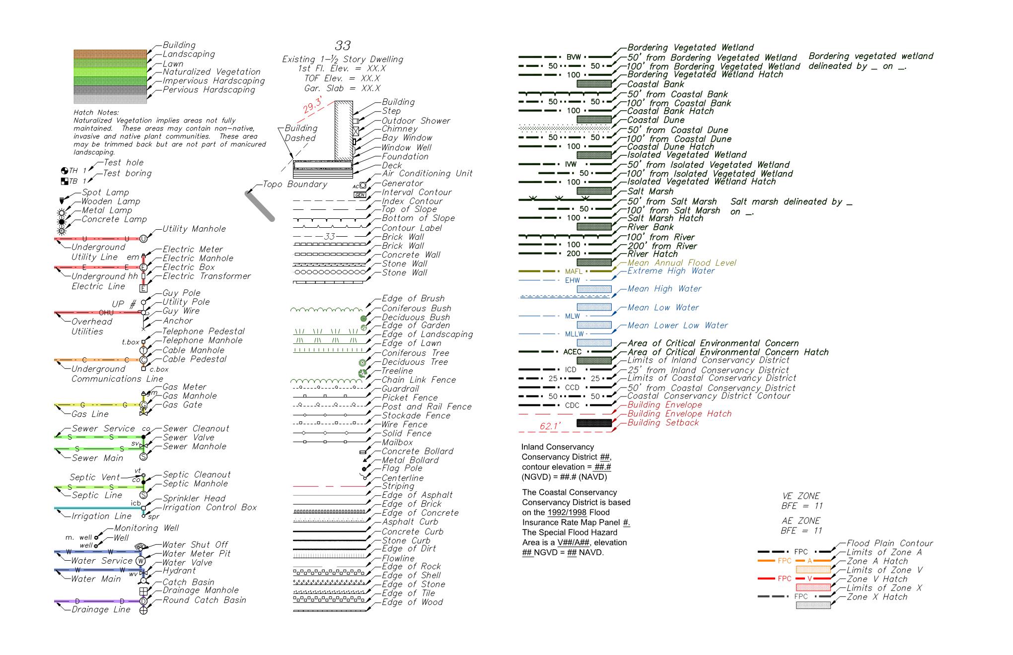
The general legend.
How many plans have been completed?
Currently we have 55% of the Town of Chatham completed. Several other areas are being processed.
Can maps be requested?
Absolutely. The contact button at the top of the page will lead you to a number of methods to contact us. We plan to do it all and we know it will take time.
Is there any value with the plans?
Yes. These plans include the underlying data that we incorporate into most surveys. Should you purchase a plan and later engage our services, the later fees will be adjusted for the work product already acquired.
Can the plans be transferred?
Yes, it would be appropriate to transfer the plans to buyers of the property or to interested parties for their efforts on a property.
Updates.
Periodically the plans will be updated. New data will be incorporated into the base files that create the plans which will result in the ability to upload updates.
Returns, Refunds, Exchanges.
If you have downloaded a plan for the wrong property, let us know and we will trade digital copies.
If you find a substantial problem in the plan, let us know and it will be remedied.
If you don’t like what you have downloaded, let us know and we will work with you to understand why. It could result in a refund less the credit card fee.
Want more information? Contact us.