
The 1858 Map of Cape Cod and the Islands is scattered with links.
Hold down the mouse left click to pan. Scroll the mouse wheel to zoom. Hold down the moujse right click to change the angle of the map.
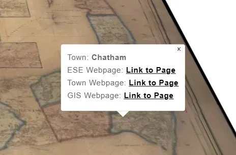
Mouse left click on a Town to access links.
ESE Webpage - Mouse left click on the Link to Page to open the ESE-LLC webmap for the Town.
Town Webpage - Mouse left click on the Link to Page to open the official Town webpage.
GIS Webpage - Mouse left click on the Link to Page to open the Town’s GIS.
This is a quick interface to access the data for each Town. If you click on an unintended Town, just mouse left click again with a bit more accuracy.