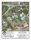
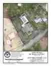
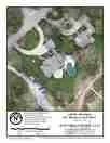
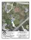
ASSESSING INFORMATION- LAST UPDATED 11-05-2018
Parcel ID: 12K-11-HC30
Assessors' Card
An aGIS map is available for this property. Click the image for the sales page or HERE for more information.


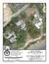
An aGIS map is available for this property. Click the image for the sales page or HERE for more information.

An aGIS map is available for this property. Click the image for the sales page or HERE for more information.

An aGIS map is available for this property. Click the image for the sales page or HERE for more information.

An aGIS map is available for this property. Click the image for the sales page or HERE for more information.
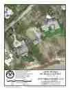
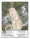
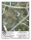
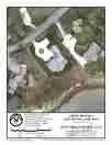
ASSESSING INFORMATION- LAST UPDATED 11-05-2018
Parcel ID: 12K-11-HC30
Assessors' Card
An aGIS map is available for this property. Click the image for the sales page or HERE for more information.
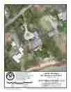
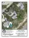
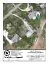
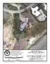
ASSESSING INFORMATION- LAST UPDATED 11-05-2018
Parcel ID: 12K-12-HC31
Assessors' Card
An aGIS map is available for this property. Click the image for the sales page or HERE for more information.
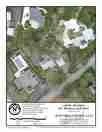
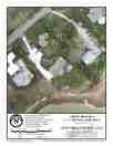
ASSESSING INFORMATION- LAST UPDATED 11-05-2018
Parcel ID: 12K-13-HC32
Assessors' Card
An aGIS map is available for this property. Click the image for the sales page or HERE for more information.
ASSESSING INFORMATION- LAST UPDATED 11-06-2018
Parcel ID: 12K-30-HC81
Assessors' Card
An aGIS map is available for this property. Click the image for the sales page or HERE for more information.
ASSESSING INFORMATION- LAST UPDATED 11-06-2018
Parcel ID: 12K-14-HC33
Assessors' Card
An aGIS map is available for this property. Click the image for the sales page or HERE for more information.
ASSESSING INFORMATION- LAST UPDATED 11-06-2018
Parcel ID: 12K-15-HC34
Assessors' Card
An aGIS map is available for this property. Click the image for the sales page or HERE for more information.
ASSESSING INFORMATION- LAST UPDATED 11-06-2018
Parcel ID: 12K-28-HC83
Assessors' Card
An aGIS map is available for this property. Click the image for the sales page or HERE for more information.
ASSESSING INFORMATION- LAST UPDATED 11-06-2018
Parcel ID: 12K-16-HC35
Assessors' Card
An aGIS map is available for this property. Click the image for the sales page or HERE for more information.
ASSESSING INFORMATION- LAST UPDATED 11-06-2018
Parcel ID: 12K-17-HC36
Assessors' Card
An aGIS map is available for this property. Click the image for the sales page or HERE for more information.
ASSESSING INFORMATION- LAST UPDATED 11-06-2018
Parcel ID: 12K-23-HC68
Assessors' Card
An aGIS map is available for this property. Click the image for the sales page or HERE for more information.
ASSESSING INFORMATION- LAST UPDATED 11-06-2018
Parcel ID: 12K-18-HC37
Assessors' Card
An aGIS map is available for this property. Click the image for the sales page or HERE for more information.
ASSESSING INFORMATION- LAST UPDATED 11-06-2018
Parcel ID: 12K-19-HC38
Assessors' Card
An aGIS map is available for this property. Click the image for the sales page or HERE for more information.
ASSESSING INFORMATION- LAST UPDATED 11-06-2018
Parcel ID: 12K-21-HC66
Assessors' Card
An aGIS map is available for this property. Click the image for the sales page or HERE for more information.
ASSESSING INFORMATION- LAST UPDATED 11-06-2018
Parcel ID: 12K-20-HC39
Assessors' Card
An aGIS map is available for this property. Click the image for the sales page or HERE for more information.
ASSESSING INFORMATION- LAST UPDATED 11-06-2018
Parcel ID: 12J-33-HC40
Assessors' Card
An aGIS map is available for this property. Click the image for the sales page or HERE for more information.
ASSESSING INFORMATION- LAST UPDATED 11-06-2018
Parcel ID: 11J-13-HC41
Assessors' Card

An aGIS map is available for this property. Click the image for the sales page or HERE for more information.