ASSESSING INFORMATION- LAST UPDATED 11-01-2018
Parcel ID: 7I-56-C348
Assessors' Card
An aGIS map is available for this property. Click the image for the sales page or HERE for more information.

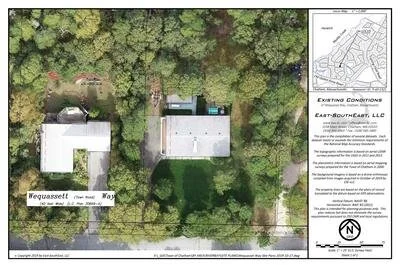
ASSESSING INFORMATION- LAST UPDATED 11-01-2018
Parcel ID: 7I-56-C348
Assessors' Card

An aGIS map is available for this property. Click the image for the sales page or HERE for more information.
ASSESSING INFORMATION- LAST UPDATED 11-01-2018
Parcel ID: 7I-63-C321
Assessors' Card
An aGIS map is available for this property. Click the image for the sales page or HERE for more information.
ASSESSING INFORMATION- LAST UPDATED 11-01-2018
Parcel ID: 7I-55-C349
Assessors' Card

An aGIS map is available for this property. Click the image for the sales page or HERE for more information.
ASSESSING INFORMATION- LAST UPDATED 11-01-2018
Parcel ID: 7I-64-C320
Assessors' Card

An aGIS map is available for this property. Click the image for the sales page or HERE for more information.
ASSESSING INFORMATION- LAST UPDATED 11-01-2018
Parcel ID: 6F-5-M14
Assessors' Card

An aGIS map is available for this property. Click the image for the sales page or HERE for more information.
ASSESSING INFORMATION- LAST UPDATED 11-01-2018
Parcel ID: 6F-6-M2
Assessors' Card

An aGIS map is available for this property. Click the image for the sales page or HERE for more information.
ASSESSING INFORMATION- LAST UPDATED 11-01-2018
Parcel ID: 6F-7-M3
Assessors' Card

An aGIS map is available for this property. Click the image for the sales page or HERE for more information.
ASSESSING INFORMATION- LAST UPDATED 11-01-2018
Parcel ID: 6F-8-M4
Assessors' Card

An aGIS map is available for this property. Click the image for the sales page or HERE for more information.
ASSESSING INFORMATION- LAST UPDATED 11-01-2018
Parcel ID: 6F-20-M17
Assessors' Card

An aGIS map is available for this property. Click the image for the sales page or HERE for more information.
ASSESSING INFORMATION- LAST UPDATED 11-01-2018
Parcel ID: 6F-19-M18
Assessors' Card

An aGIS map is available for this property. Click the image for the sales page or HERE for more information.
ASSESSING INFORMATION- LAST UPDATED 11-01-2018
Parcel ID: 6F-9-M5
Assessors' Card

An aGIS map is available for this property. Click the image for the sales page or HERE for more information.
ASSESSING INFORMATION- LAST UPDATED 11-01-2018
Parcel ID: 6F-10-M6
Assessors' Card


An aGIS map is available for this property. Click the image for the sales page or HERE for more information.
ASSESSING INFORMATION- LAST UPDATED 11-01-2018
Parcel ID: 6F-18-M19
Assessors' Card

An aGIS map is available for this property. Click the image for the sales page or HERE for more information.
ASSESSING INFORMATION- LAST UPDATED 11-01-2018
Parcel ID: 6F-11-M7
Assessors' Card

An aGIS map is available for this property. Click the image for the sales page or HERE for more information.
ASSESSING INFORMATION- LAST UPDATED 11-01-2018
Parcel ID: 6F-17-M20
Assessors' Card

An aGIS map is available for this property. Click the image for the sales page or HERE for more information.
ASSESSING INFORMATION- LAST UPDATED 11-01-2018
Parcel ID: 6F-12-M8
Assessors' Card

An aGIS map is available for this property. Click the image for the sales page or HERE for more information.
ASSESSING INFORMATION- LAST UPDATED 11-01-2018
Parcel ID: 6F-16-M21
Assessors' Card

An aGIS map is available for this property. Click the image for the sales page or HERE for more information.
ASSESSING INFORMATION- LAST UPDATED 11-01-2018
Parcel ID: 6F-13-M9
Assessors' Card

An aGIS map is available for this property. Click the image for the sales page or HERE for more information.
ASSESSING INFORMATION- LAST UPDATED 11-01-2018
Parcel ID: 6F-15-M22
Assessors' Card

An aGIS map is available for this property. Click the image for the sales page or HERE for more information.
ASSESSING INFORMATION- LAST UPDATED 11-01-2018
Parcel ID: 6G-1-M10
Assessors' Card

An aGIS map is available for this property. Click the image for the sales page or HERE for more information.