ASSESSING INFORMATION- LAST UPDATED 10-30-2018
Parcel ID: 10E-28-D62
Assessors' Card
An aGIS map is available for this property. Click the image for the sales page or HERE for more information.


ASSESSING INFORMATION- LAST UPDATED 10-30-2018
Parcel ID: 10E-28-D62
Assessors' Card

An aGIS map is available for this property. Click the image for the sales page or HERE for more information.

ASSESSING INFORMATION- LAST UPDATED 10-30-2018
Parcel ID: 10E-32-69
Assessors' Card
An aGIS map is available for this property. Click the image for the sales page or HERE for more information.

ASSESSING INFORMATION- LAST UPDATED 10-30-2018
Parcel ID: 10E-31-D59
Assessors' Card

An aGIS map is available for this property. Click the image for the sales page or HERE for more information.

ASSESSING INFORMATION- LAST UPDATED 10-30-2018
Parcel ID: 10D-53-C
Assessors' Card

An aGIS map is available for this property. Click the image for the sales page or HERE for more information.

ASSESSING INFORMATION- LAST UPDATED 10-30-2018
Parcel ID: 10D-64-D53
Assessors' Card

An aGIS map is available for this property. Click the image for the sales page or HERE for more information.

ASSESSING INFORMATION- LAST UPDATED 10-30-2018
Parcel ID: 10D-52-DR3
Assessors' Card

An aGIS map is available for this property. Click the image for the sales page or HERE for more information.

ASSESSING INFORMATION- LAST UPDATED 10-30-2018
Parcel ID: 10D-51-DR3B
Assessors' Card

An aGIS map is available for this property. Click the image for the sales page or HERE for more information.
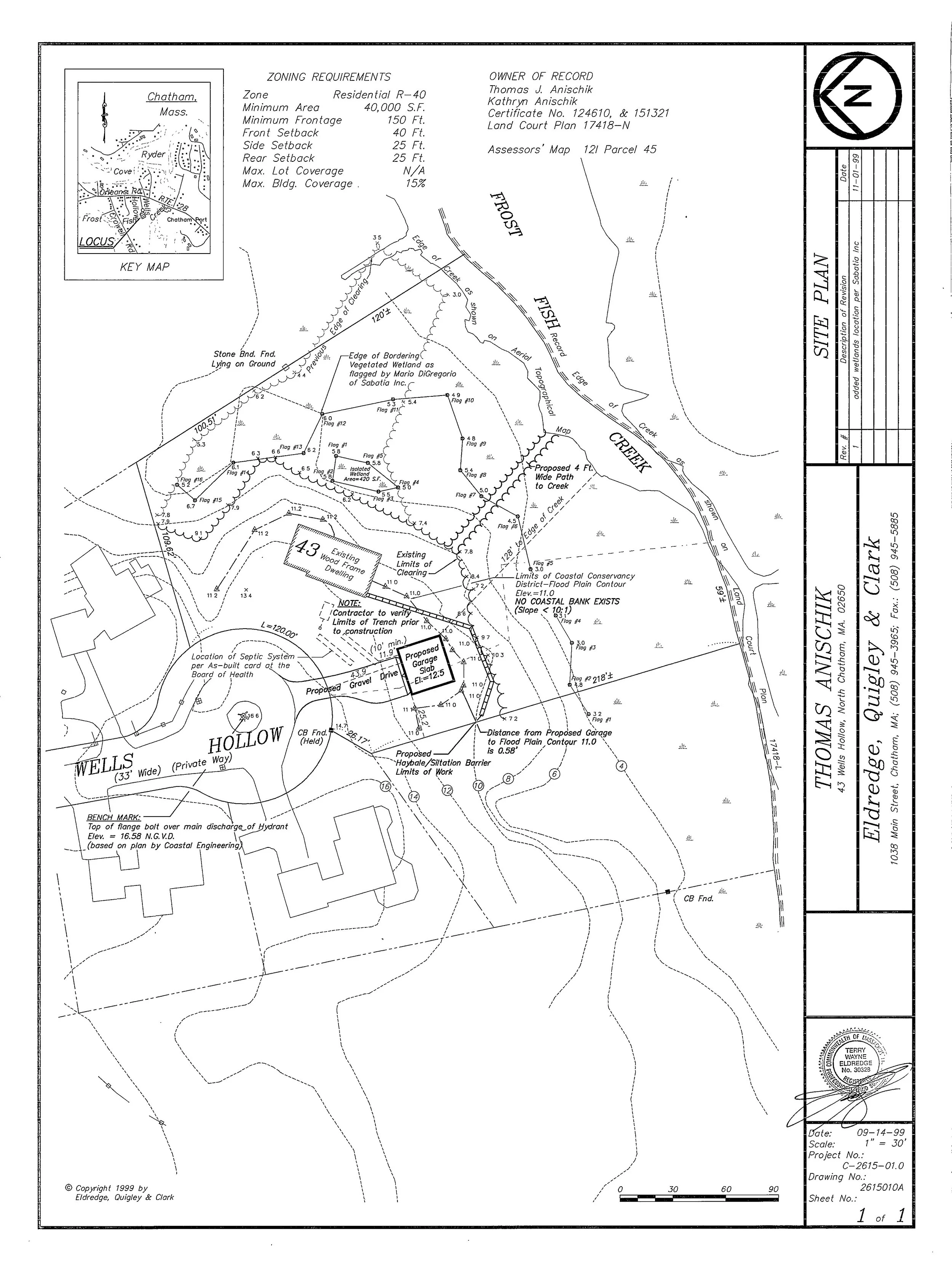
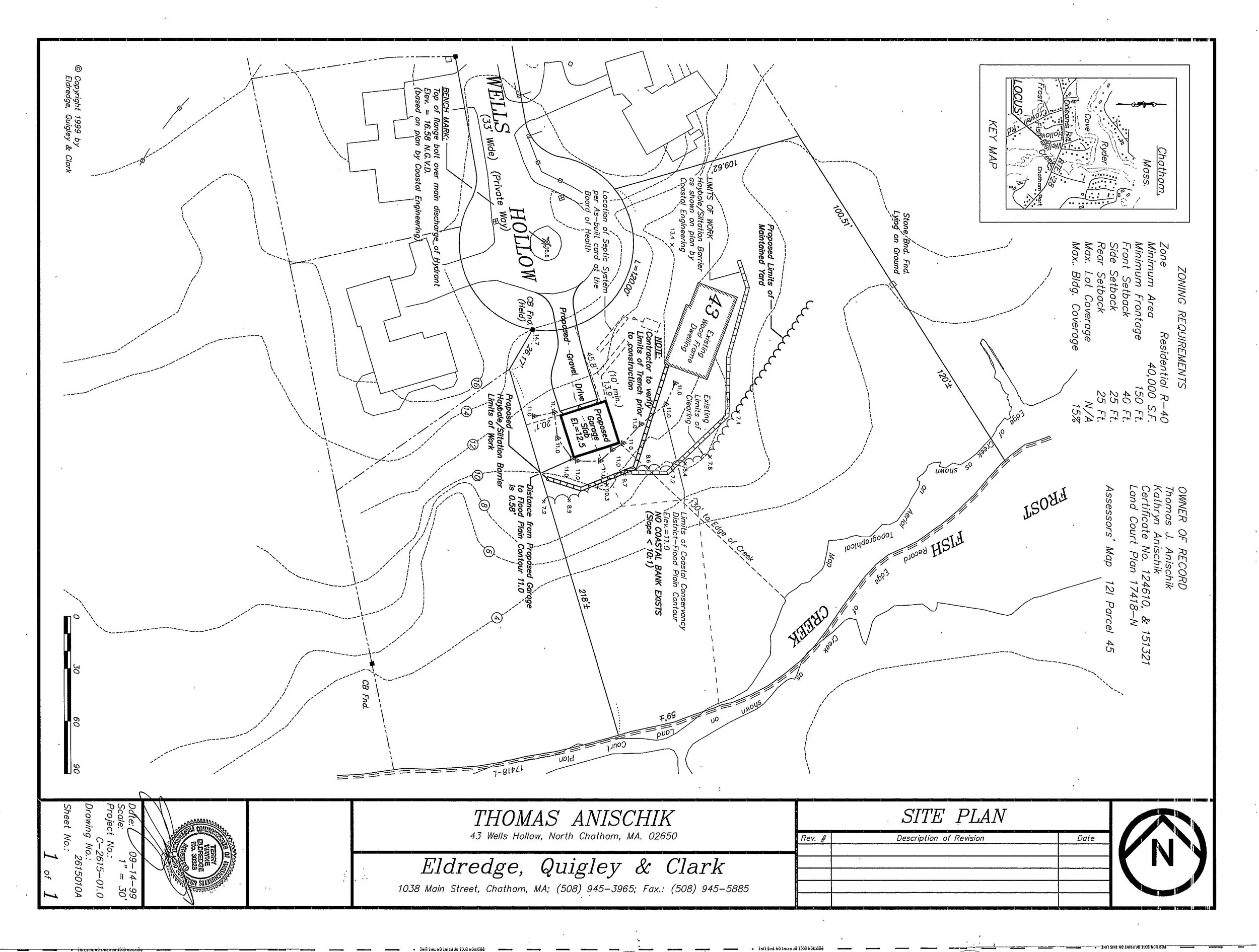
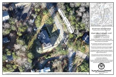
ASSESSING INFORMATION- LAST UPDATED 10-30-2018
Parcel ID: 12J-17A-GB36
Assessors' Card
ASSESSING INFORMATION- LAST UPDATED 10-30-2018
Parcel ID: 12I-9-GB37
Assessors' Card
ASSESSING INFORMATION- LAST UPDATED 10-30-2018
Parcel ID: 12I-9A-GB38
Assessors' Card
ASSESSING INFORMATION- LAST UPDATED 10-30-2018
Parcel ID: 12I-9F-GB43
Assessors' Card
ASSESSING INFORMATION- LAST UPDATED 10-30-2018
Parcel ID: 12I-9B-GB39
Assessors' Card
ASSESSING INFORMATION- LAST UPDATED 10-30-2018
Parcel ID: 12I-9C-GB40
Assessors' Card
ASSESSING INFORMATION- LAST UPDATED 11-01-2018
Parcel ID: 14J-42-R50
Assessors' Card

An aGIS map is available for this property. Click the image for the sales page or HERE for more information.
ASSESSING INFORMATION- LAST UPDATED 11-01-2018
Parcel ID: 14J-51-R35
Assessors' Card
An aGIS map is available for this property. Click the image for the sales page or HERE for more information.