ASSESSING INFORMATION- LAST UPDATED 10-30-2018
Parcel ID: 3D-64G-J6
Assessors' Card
aGIS or accurate GIS is an existing conditions plan exceeding the National Map Accuracy Standards with portions meeting the Survey Standards of 250 CMR.

ASSESSING INFORMATION- LAST UPDATED 10-30-2018
Parcel ID: 3D-64G-J6
Assessors' Card

aGIS or accurate GIS is an existing conditions plan exceeding the National Map Accuracy Standards with portions meeting the Survey Standards of 250 CMR.
ASSESSING INFORMATION- LAST UPDATED 10-30-2018
Parcel ID: 3D-64C-J4
Assessors' Card

aGIS or accurate GIS is an existing conditions plan exceeding the National Map Accuracy Standards with portions meeting the Survey Standards of 250 CMR.
ASSESSING INFORMATION- LAST UPDATED 10-30-2018
Parcel ID: 3D-64D-J8
Assessors' Card

aGIS or accurate GIS is an existing conditions plan exceeding the National Map Accuracy Standards with portions meeting the Survey Standards of 250 CMR.
ASSESSING INFORMATION- LAST UPDATED 10-30-2018
Parcel ID: 3D-64F-J7
Assessors' Card

aGIS or accurate GIS is an existing conditions plan exceeding the National Map Accuracy Standards with portions meeting the Survey Standards of 250 CMR.
ASSESSING INFORMATION- LAST UPDATED 10-30-2018
Parcel ID: 3D-64E-J9
Assessors' Card

aGIS or accurate GIS is an existing conditions plan exceeding the National Map Accuracy Standards with portions meeting the Survey Standards of 250 CMR.

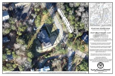
An aGIS map is available for this property. Click the image for the sales page or HERE for more information.

An aGIS map is available for this property. Click the image for the sales page or HERE for more information.


ASSESSING INFORMATION- LAST UPDATED 10-30-2018
Parcel ID: 10E-28-D62
Assessors' Card

An aGIS map is available for this property. Click the image for the sales page or HERE for more information.

ASSESSING INFORMATION- LAST UPDATED 10-30-2018
Parcel ID: 10E-32-69
Assessors' Card
An aGIS map is available for this property. Click the image for the sales page or HERE for more information.

ASSESSING INFORMATION- LAST UPDATED 10-30-2018
Parcel ID: 10E-31-D59
Assessors' Card

An aGIS map is available for this property. Click the image for the sales page or HERE for more information.

ASSESSING INFORMATION- LAST UPDATED 10-30-2018
Parcel ID: 10D-53-C
Assessors' Card

An aGIS map is available for this property. Click the image for the sales page or HERE for more information.

ASSESSING INFORMATION- LAST UPDATED 10-30-2018
Parcel ID: 10D-64-D53
Assessors' Card

An aGIS map is available for this property. Click the image for the sales page or HERE for more information.

ASSESSING INFORMATION- LAST UPDATED 10-30-2018
Parcel ID: 10D-52-DR3
Assessors' Card

An aGIS map is available for this property. Click the image for the sales page or HERE for more information.

ASSESSING INFORMATION- LAST UPDATED 10-30-2018
Parcel ID: 10D-51-DR3B
Assessors' Card

An aGIS map is available for this property. Click the image for the sales page or HERE for more information.
ASSESSING INFORMATION- LAST UPDATED 10-30-2018
Parcel ID: 12J-17A-GB36
Assessors' Card
ASSESSING INFORMATION- LAST UPDATED 10-30-2018
Parcel ID: 12I-9-GB37
Assessors' Card