ASSESSING INFORMATION- LAST UPDATED 10-30-2018
Parcel ID: 2A-59-29
Assessors' Card
aGIS or accurate GIS is an existing conditions plan exceeding the National Map Accuracy Standards with portions meeting the Survey Standards of 250 CMR.

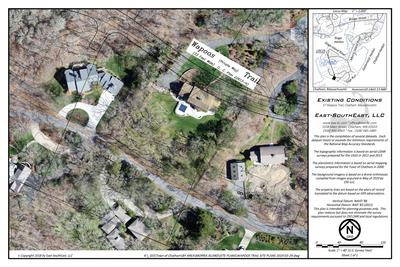
ASSESSING INFORMATION- LAST UPDATED 10-30-2018
Parcel ID: 2A-59-29
Assessors' Card

aGIS or accurate GIS is an existing conditions plan exceeding the National Map Accuracy Standards with portions meeting the Survey Standards of 250 CMR.
ASSESSING INFORMATION- LAST UPDATED 10-30-2018
Parcel ID: 2A-34-14
Assessors' Card

aGIS or accurate GIS is an existing conditions plan exceeding the National Map Accuracy Standards with portions meeting the Survey Standards of 250 CMR.
ASSESSING INFORMATION- LAST UPDATED 10-30-2018
Parcel ID: 2A-58-30
Assessors' Card

aGIS or accurate GIS is an existing conditions plan exceeding the National Map Accuracy Standards with portions meeting the Survey Standards of 250 CMR.
ASSESSING INFORMATION- LAST UPDATED 10-30-2018
Parcel ID: 2A-35-17
Assessors' Card

An aGIS map is available for this property. Click the image for the sales page or HERE for more information.
ASSESSING INFORMATION- LAST UPDATED 10-30-2018
Parcel ID: 14A3-12A-N162
Assessors' Card

An aGIS map is available for this property. Click the image for the sales page or HERE for more information.
ASSESSING INFORMATION- LAST UPDATED 10-30-2018
Parcel ID: 14A3-18-N67
Assessors' Card

An aGIS map is available for this property. Click the image for the sales page or HERE for more information.
ASSESSING INFORMATION- LAST UPDATED 10-30-2018
Parcel ID: 14A3-12-N88
Assessors' Card

An aGIS map is available for this property. Click the image for the sales page or HERE for more information.
ASSESSING INFORMATION- LAST UPDATED 10-30-2018
Parcel ID: 14A3-13-N89
Assessors' Card
An aGIS map is available for this property. Click the image for the sales page or HERE for more information.
ASSESSING INFORMATION- LAST UPDATED 10-30-2018
Parcel ID: 14A3-14-N141
Assessors' Card

An aGIS map is available for this property. Click the image for the sales page or HERE for more information.
ASSESSING INFORMATION- LAST UPDATED 10-30-2018
Parcel ID: 14A3-15-N64
Assessors' Card

An aGIS map is available for this property. Click the image for the sales page or HERE for more information.
ASSESSING INFORMATION- LAST UPDATED 10-30-2018
Parcel ID: 13A3-1-N140
Assessors' Card

An aGIS map is available for this property. Click the image for the sales page or HERE for more information.
ASSESSING INFORMATION- LAST UPDATED 10-30-2018
Parcel ID: 13A3-2-N164
Assessors' Card

An aGIS map is available for this property. Click the image for the sales page or HERE for more information.
ASSESSING INFORMATION- LAST UPDATED 10-30-2018
Parcel ID: 13A2-9-N163
Assessors' Card

An aGIS map is available for this property. Click the image for the sales page or HERE for more information.
ASSESSING INFORMATION- LAST UPDATED 10-30-2018
Parcel ID: 14A2-8-N174
Assessors' Card

An aGIS map is available for this property. Click the image for the sales page or HERE for more information.
ASSESSING INFORMATION- LAST UPDATED 10-30-2018
Parcel ID: 13A2-8-N142
Assessors' Card

An aGIS map is available for this property. Click the image for the sales page or HERE for more information.

An aGIS map is available for this property. Click the image for the sales page or HERE for more information.
ASSESSING INFORMATION- LAST UPDATED 10-30-2018
Parcel ID: 13A2-10-N143
Assessors' Card

An aGIS map is available for this property. Click the image for the sales page or HERE for more information.
ASSESSING INFORMATION- LAST UPDATED 10-30-2018
Parcel ID: 7F-3-M44
Assessors' Card
ASSESSING INFORMATION- LAST UPDATED 10-30-2018
Parcel ID: 7G-59-M49
Assessors' Card