ASSESSING INFORMATION- LAST UPDATED 10-23-2018
Parcel ID: 11E-24A-13B
Assessors' Card
An aGIS map is available for this property. Click the image for the sales page or HERE for more information.


ASSESSING INFORMATION- LAST UPDATED 10-23-2018
Parcel ID: 11E-24A-13B
Assessors' Card

An aGIS map is available for this property. Click the image for the sales page or HERE for more information.

ASSESSING INFORMATION- LAST UPDATED 10-23-2018
Parcel ID: 11E-23A-R5
Assessors' Card

An aGIS map is available for this property. Click the image for the sales page or HERE for more information.

ASSESSING INFORMATION- LAST UPDATED 10-23-2018
Parcel ID: 11E-24-13
Assessors' Card

An aGIS map is available for this property. Click the image for the sales page or HERE for more information.

ASSESSING INFORMATION- LAST UPDATED 10-23-2018
Parcel ID: 11E-23-28
Assessors' Card

An aGIS map is available for this property. Click the image for the sales page or HERE for more information.

ASSESSING INFORMATION- LAST UPDATED 10-23-2018
Parcel ID: 12D-23-1
Assessors' Card

An aGIS map is available for this property. Click the image for the sales page or HERE for more information.

ASSESSING INFORMATION- LAST UPDATED 10-23-2018
Parcel ID: 12E-2A-R6
Assessors' Card

An aGIS map is available for this property. Click the image for the sales page or HERE for more information.

ASSESSING INFORMATION- LAST UPDATED 10-23-2018
Parcel ID: 12E-2B-R6B
Assessors' Card

An aGIS map is available for this property. Click the image for the sales page or HERE for more information.


ASSESSING INFORMATION- LAST UPDATED 10-23-2018
Parcel ID: 12E-3-RC
Assessors' Card

An aGIS map is available for this property. Click the image for the sales page or HERE for more information.


An aGIS map is available for this property. Click the image for the sales page or HERE for more information.
View analysis
How to read the video:
The surface model was created from aerial lidar data (laser scan data). The points obtained from the lidar scan are a couple feet apart and each point has a vertical accuracy of about half a foot. The model is close but contains some obvious deformations.
The trees are modeled from the top down. In many cases, especially with deciduous trees, the sightlines may be better than those determined by this method of modeling.
The burnt orange areas are those visible from the marker annotated MyMarker1. The scenes include various states of clearing within the lots and proposed easement.

This is a preliminary profile of the line of sight from about 5' above the ground at the Bouden's house to a point in the water that is visible without being shadowed by the existing hillside.
ASSESSING INFORMATION- LAST UPDATED 10-23-2018
Parcel ID: 12E-2B-7B
Assessors' Card

An aGIS map is available for this property. Click the image for the sales page or HERE for more information.
ASSESSING INFORMATION- LAST UPDATED 10-29-2018
Parcel ID: 4D-22-A21
Assessors' Card

An aGIS map is available for this property. Click the image for the sales page or HERE for more information.
ASSESSING INFORMATION- LAST UPDATED 10-29-2018
Parcel ID: 4D-6-A2
Assessors' Card

An aGIS map is available for this property. Click the image for the sales page or HERE for more information.
ASSESSING INFORMATION- LAST UPDATED 10-29-2018
Parcel ID: 4D-7-A3
Assessors' Card

An aGIS map is available for this property. Click the image for the sales page or HERE for more information.
ASSESSING INFORMATION- LAST UPDATED 10-29-2018
Parcel ID: 4D-21-A16
Assessors' Card
ASSESSING INFORMATION- LAST UPDATED 10-29-2018
Parcel ID: 4D-8-A4
Assessors' Card


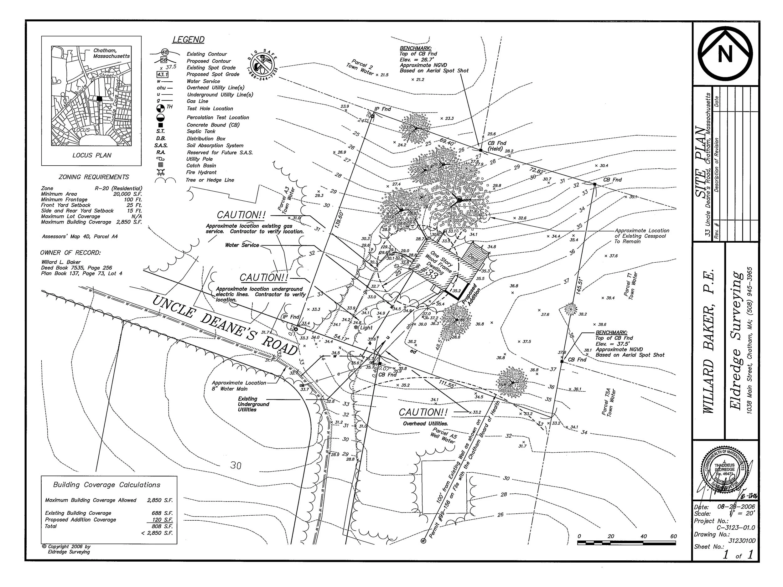
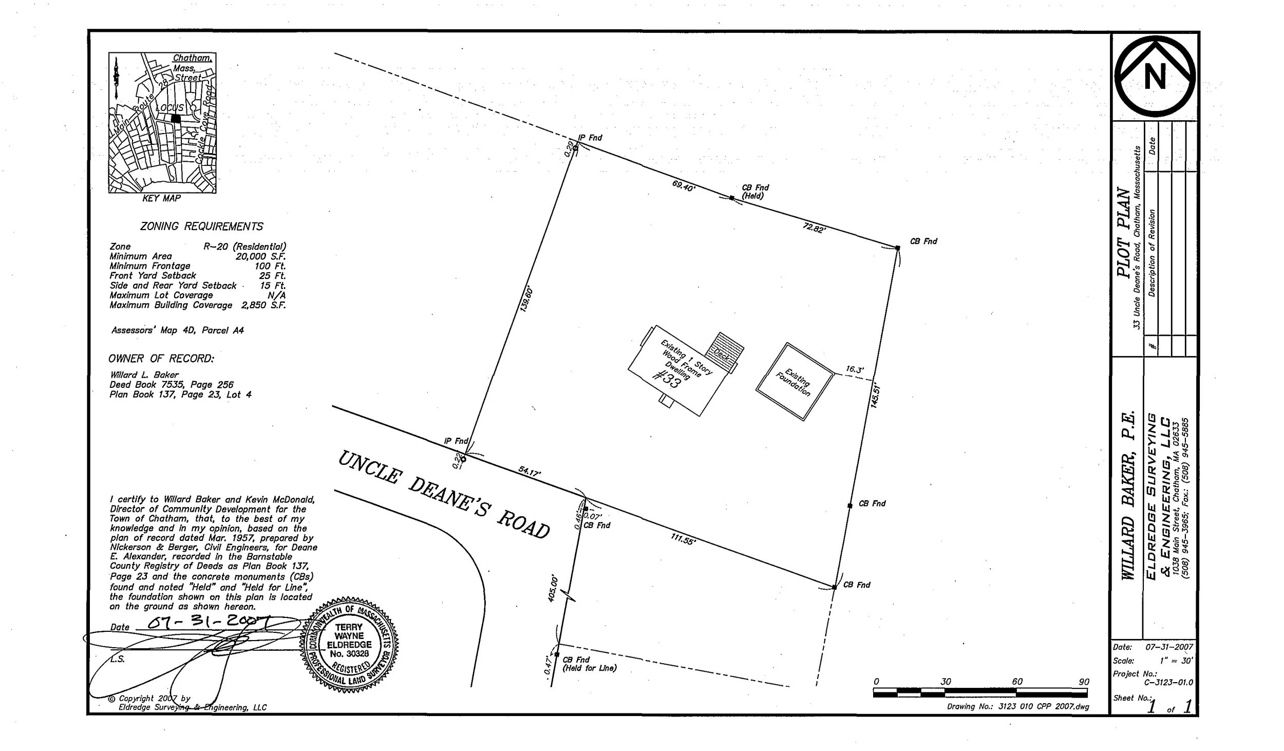
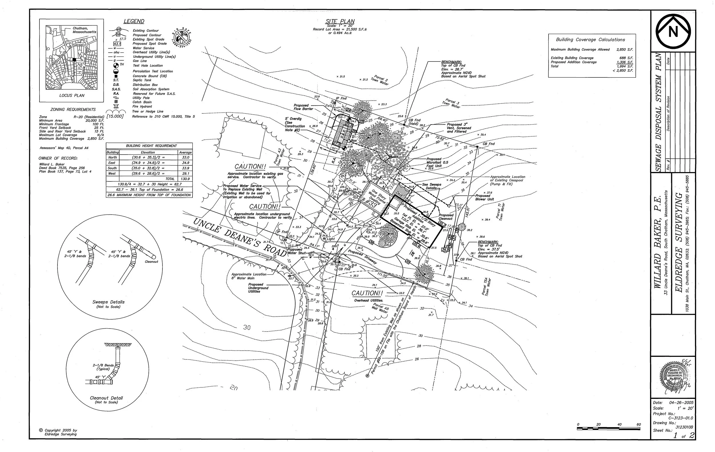


An aGIS map is available for this property. Click the image for the sales page or HERE for more information.
ASSESSING INFORMATION- LAST UPDATED 10-29-2018
Parcel ID: 4D-9-A5
Assessors' Card

An aGIS map is available for this property. Click the image for the sales page or HERE for more information.
ASSESSING INFORMATION- LAST UPDATED 10-29-2018
Parcel ID: 4D-10-A6
Assessors' Card

An aGIS map is available for this property. Click the image for the sales page or HERE for more information.
ASSESSING INFORMATION- LAST UPDATED 10-29-2018
Parcel ID: 4D-20-A15
Assessors' Card

An aGIS map is available for this property. Click the image for the sales page or HERE for more information.
ASSESSING INFORMATION- LAST UPDATED 10-29-2018
Parcel ID: 4D-11-A7
Assessors' Card

An aGIS map is available for this property. Click the image for the sales page or HERE for more information.
ASSESSING INFORMATION- LAST UPDATED 10-29-2018
Parcel ID: 4D-19-A14
Assessors' Card

An aGIS map is available for this property. Click the image for the sales page or HERE for more information.