
ASSESSING INFORMATION- LAST UPDATED 10-18-2018
Parcel ID: 3D-29-29
Assessors' Card
13E-20-R13 Tabitha Ter
2 Tabitha Ter

ASSESSING INFORMATION- LAST UPDATED 10-18-2018
Parcel ID: 13E-23-R16
Assessors' Card

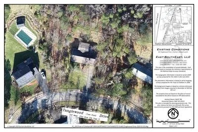
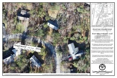
aGIS or accurate GIS is an existing conditions plan exceeding the National Map Accuracy Standards with portions meeting the Survey Standards of 250 CMR.
8 Tabitha Ter

ASSESSING INFORMATION- LAST UPDATED 10-18-2018
Parcel ID: 13E-22-R15
Assessors' Card

aGIS or accurate GIS is an existing conditions plan exceeding the National Map Accuracy Standards with portions meeting the Survey Standards of 250 CMR.
20 Tabitha Ter

ASSESSING INFORMATION- LAST UPDATED 10-18-2018
Parcel ID: 13E-21-R14
Assessors' Card

aGIS or accurate GIS is an existing conditions plan exceeding the National Map Accuracy Standards with portions meeting the Survey Standards of 250 CMR.
38 Tabitha Ter

ASSESSING INFORMATION- LAST UPDATED 10-18-2018
Parcel ID: 13E-19-R12
Assessors' Card

aGIS or accurate GIS is an existing conditions plan exceeding the National Map Accuracy Standards with portions meeting the Survey Standards of 250 CMR.
11 Tanglewood Dr
ASSESSING INFORMATION- LAST UPDATED 10-18-2018
Parcel ID: 4H-6-T19
Assessors' Card


An aGIS map is available for this property. Click the image for the sales page or HERE for more information.
16 Tanglewood Dr
ASSESSING INFORMATION- LAST UPDATED 10-18-2018
Parcel ID: 4H-6G-T1
Assessors' Card

An aGIS map is available for this property. Click the image for the sales page or HERE for more information.
40 Tanglewood Dr
ASSESSING INFORMATION- LAST UPDATED 10-18-2018
Parcel ID: 4H-6F-T2
Assessors' Card

An aGIS map is available for this property. Click the image for the sales page or HERE for more information.
55 Tanglewood Dr
ASSESSING INFORMATION- LAST UPDATED 10-18-2018
Parcel ID: 4H-6D-T21
Assessors' Card

An aGIS map is available for this property. Click the image for the sales page or HERE for more information.
60 Tanglewood Dr
ASSESSING INFORMATION- LAST UPDATED 10-18-2018
Parcel ID: 5H-4K-T22
Assessors' Card

An aGIS map is available for this property. Click the image for the sales page or HERE for more information.
70 Tanglewood Dr
ASSESSING INFORMATION- LAST UPDATED 10-18-2018
Parcel ID: 5H-4A-T4
Assessors' Card
75 Tanglewood Dr
ASSESSING INFORMATION- LAST UPDATED 10-18-2018
Parcel ID: 5H-4J-T23
Assessors' Card

An aGIS map is available for this property. Click the image for the sales page or HERE for more information.
86 Tanglewood Dr
ASSESSING INFORMATION- LAST UPDATED 10-18-2018
Parcel ID: 5H-4B-T5
Assessors' Card


An aGIS map is available for this property. Click the image for the sales page or HERE for more information.
95 Tanglewood Dr
ASSESSING INFORMATION- LAST UPDATED 10-18-2018
Parcel ID: 5H-4I-T24
Assessors' Card

An aGIS map is available for this property. Click the image for the sales page or HERE for more information.
100 Tanglewood Dr
ASSESSING INFORMATION- LAST UPDATED 10-18-2018
Parcel ID: 5H-4C-T6
Assessors' Card
An aGIS map is available for this property. Click the image for the sales page or HERE for more information.
110 Tanglewood Dr
ASSESSING INFORMATION- LAST UPDATED 10-18-2018
Parcel ID: 5H-4D-T7
Assessors' Card

An aGIS map is available for this property. Click the image for the sales page or HERE for more information.
126 Tanglewood Dr
ASSESSING INFORMATION- LAST UPDATED 10-18-2018
Parcel ID: 5H-4E-T8
Assessors' Card

An aGIS map is available for this property. Click the image for the sales page or HERE for more information.
135 Tanglewood Dr
ASSESSING INFORMATION- LAST UPDATED 10-18-2018
Parcel ID: 5H-4H-T25
Assessors' Card

An aGIS map is available for this property. Click the image for the sales page or HERE for more information.
140 Tanglewood Dr
ASSESSING INFORMATION- LAST UPDATED 10-18-2018
Parcel ID: 5H-4F-T9
Assessors' Card

An aGIS map is available for this property. Click the image for the sales page or HERE for more information.