ASSESSING INFORMATION- LAST UPDATED 10-18-2018
Parcel ID: 6D-65-X11
Assessors' Card
An aGIS map is available for this property. Click the image for the sales page or HERE for more information.

ASSESSING INFORMATION- LAST UPDATED 10-18-2018
Parcel ID: 6D-65-X11
Assessors' Card

An aGIS map is available for this property. Click the image for the sales page or HERE for more information.
ASSESSING INFORMATION- LAST UPDATED 10-18-2018
Parcel ID: 7H-5-51
Assessors' Card

An aGIS map is available for this property. Click the image for the sales page or HERE for more information.
ASSESSING INFORMATION- LAST UPDATED 10-18-2018
Parcel ID: 7H-4-S2
Assessors' Card

An aGIS map is available for this property. Click the image for the sales page or HERE for more information.
ASSESSING INFORMATION- LAST UPDATED 10-18-2018
Parcel ID: 7H-3-S3
Assessors' Card

An aGIS map is available for this property. Click the image for the sales page or HERE for more information.
ASSESSING INFORMATION- LAST UPDATED 10-18-2018
Parcel ID: 7H-2-S4
Assessors' Card

An aGIS map is available for this property. Click the image for the sales page or HERE for more information.
map is available for this property. Click the image for the sales page or HERE for more information.
ASSESSING INFORMATION- LAST UPDATED 10-18-2018
Parcel ID: 9K-14-LP17
Assessors' Card

map is available for this property. Click the image for the sales page or HERE for more information.
ASSESSING INFORMATION- LAST UPDATED 10-18-2018
Parcel ID: 9K-17-LP10
Assessors' Card
map is available for this property. Click the image for the sales page or HERE for more information.
ASSESSING INFORMATION- LAST UPDATED 10-18-2018
Parcel ID: 9K-16-LP11
Assessors' Card

map is available for this property. Click the image for the sales page or HERE for more information.
ASSESSING INFORMATION- LAST UPDATED 10-18-2018
Parcel ID: 9J-1A-LP12
Assessors' Card
map is available for this property. Click the image for the sales page or HERE for more information.
ASSESSING INFORMATION- LAST UPDATED 10-18-2018
Parcel ID: 3D-58-28
Assessors' Card
ASSESSING INFORMATION- LAST UPDATED 10-18-2018
Parcel ID: 4D-1-33
Assessors' Card
ASSESSING INFORMATION- LAST UPDATED 10-18-2018
Parcel ID: 3D-29-29
Assessors' Card

ASSESSING INFORMATION- LAST UPDATED 10-18-2018
Parcel ID: 13E-23-R16
Assessors' Card

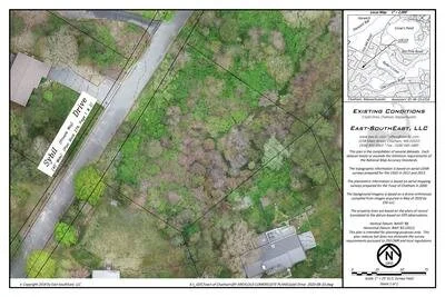
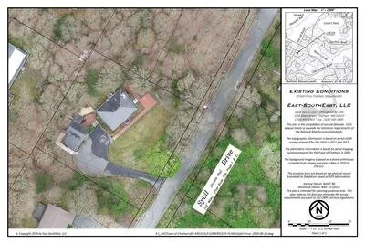
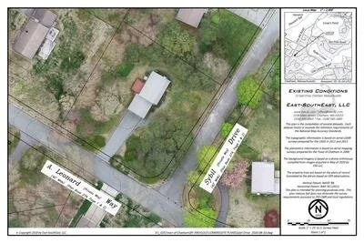
aGIS or accurate GIS is an existing conditions plan exceeding the National Map Accuracy Standards with portions meeting the Survey Standards of 250 CMR.

ASSESSING INFORMATION- LAST UPDATED 10-18-2018
Parcel ID: 13E-22-R15
Assessors' Card

aGIS or accurate GIS is an existing conditions plan exceeding the National Map Accuracy Standards with portions meeting the Survey Standards of 250 CMR.

ASSESSING INFORMATION- LAST UPDATED 10-18-2018
Parcel ID: 13E-21-R14
Assessors' Card

aGIS or accurate GIS is an existing conditions plan exceeding the National Map Accuracy Standards with portions meeting the Survey Standards of 250 CMR.

ASSESSING INFORMATION- LAST UPDATED 10-18-2018
Parcel ID: 13E-19-R12
Assessors' Card

aGIS or accurate GIS is an existing conditions plan exceeding the National Map Accuracy Standards with portions meeting the Survey Standards of 250 CMR.
ASSESSING INFORMATION- LAST UPDATED 10-18-2018
Parcel ID: 4H-6-T19
Assessors' Card


An aGIS map is available for this property. Click the image for the sales page or HERE for more information.
ASSESSING INFORMATION- LAST UPDATED 10-18-2018
Parcel ID: 4H-6G-T1
Assessors' Card

An aGIS map is available for this property. Click the image for the sales page or HERE for more information.