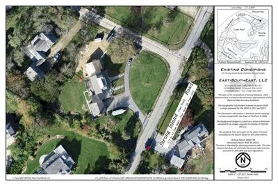
ASSESSING INFORMATION- LAST UPDATED 10-18-2018
Parcel ID: 12M-16-B19
Assessors' Card
An aGIS map is available for this property. Click the image for the sales page or HERE for more information.


An aGIS map is available for this property. Click the image for the sales page or HERE for more information.

An aGIS map is available for this property. Click the image for the sales page or HERE for more information.

An aGIS map is available for this property. Click the image for the sales page or HERE for more information.

An aGIS map is available for this property. Click the image for the sales page or HERE for more information.
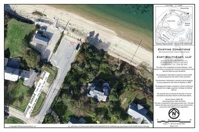
ASSESSING INFORMATION- LAST UPDATED 10-18-2018
Parcel ID: 12M-16-B19
Assessors' Card

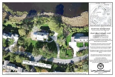
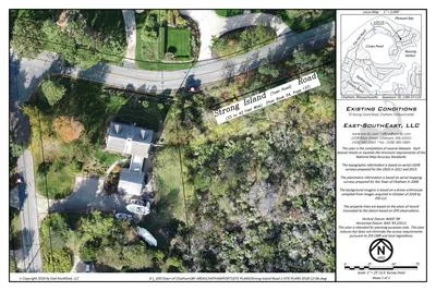
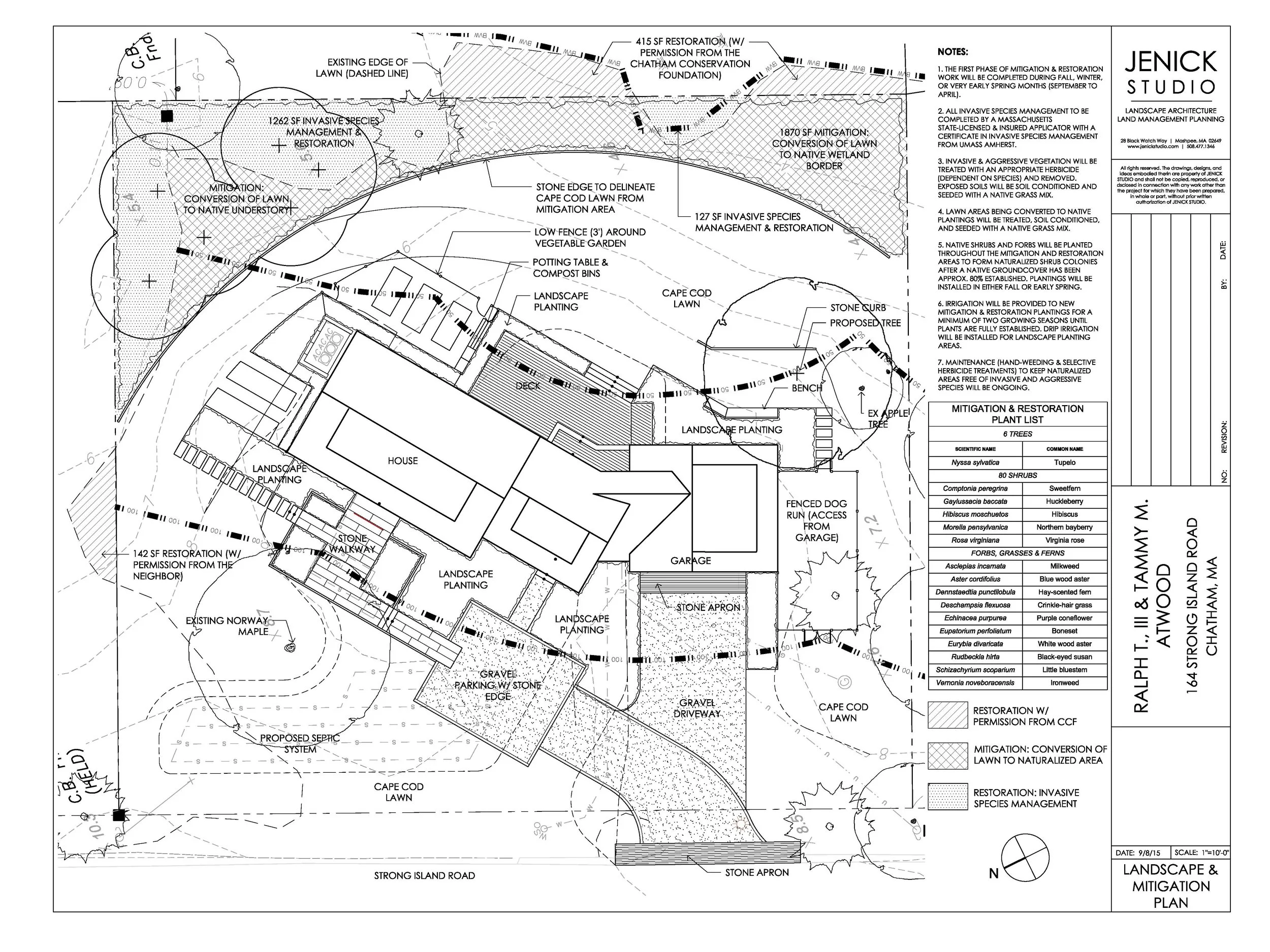
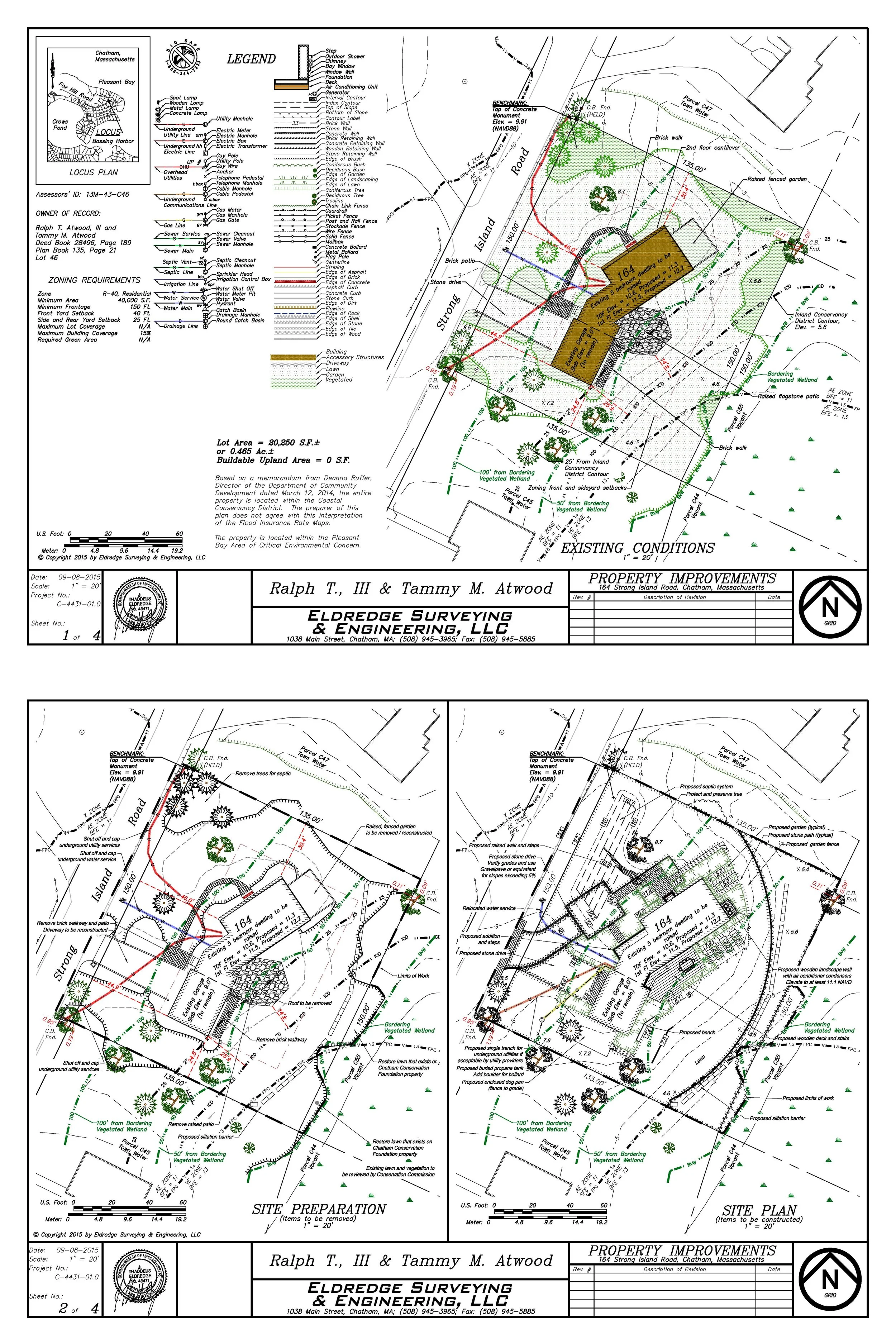
An aGIS map is available for this property. Click the image for the sales page or HERE for more information.
Plans revised to remove driveway improvements.


Land Management Plan

An aGIS map is available for this property. Click the image for the sales page or HERE for more information.
ASSESSING INFORMATION- LAST UPDATED 10-18-2018
Parcel ID: 12M-17-B18
Assessors' Card

An aGIS map is available for this property. Click the image for the sales page or HERE for more information.

ASSESSING INFORMATION- LAST UPDATED 10-18-2018
Parcel ID: 12M-18-C8
Assessors' Card
An aGIS map is available for this property. Click the image for the sales page or HERE for more information.
ASSESSING INFORMATION- LAST UPDATED 10-18-2018
Parcel ID: 13M-57-B17
Assessors' Card
An aGIS map is available for this property. Click the image for the sales page or HERE for more information.
ASSESSING INFORMATION- LAST UPDATED 10-18-2018
Parcel ID: 13M-37-C14
Assessors' Card
An aGIS map is available for this property. Click the image for the sales page or HERE for more information.
ASSESSING INFORMATION- LAST UPDATED 10-18-2018
Parcel ID: 13M-56-B16
Assessors' Card

An aGIS map is available for this property. Click the image for the sales page or HERE for more information.
ASSESSING INFORMATION- LAST UPDATED 10-18-2018
Parcel ID: 13M-55-B15
Assessors' Card

An aGIS map is available for this property. Click the image for the sales page or HERE for more information.
ASSESSING INFORMATION- LAST UPDATED 10-18-2018
Parcel ID: 13M-54-B14
Assessors' Card

An aGIS map is available for this property. Click the image for the sales page or HERE for more information.
ASSESSING INFORMATION- LAST UPDATED 10-18-2018
Parcel ID: 13M-53-B13
Assessors' Card

An aGIS map is available for this property. Click the image for the sales page or HERE for more information.
ASSESSING INFORMATION- LAST UPDATED 10-18-2018
Parcel ID: 13M-43-C46
Assessors' Card

An aGIS map is available for this property. Click the image for the sales page or HERE for more information.


ASSESSING INFORMATION- LAST UPDATED 10-18-2018
Parcel ID: 13M-52-11
Assessors' Card
An aGIS map is available for this property. Click the image for the sales page or HERE for more information.
ASSESSING INFORMATION- LAST UPDATED 10-18-2018
Parcel ID: 13M-44-C47
Assessors' Card

An aGIS map is available for this property. Click the image for the sales page or HERE for more information.
ASSESSING INFORMATION- LAST UPDATED 10-18-2018
Parcel ID: 13M-45-C48
Assessors' Card
An aGIS map is available for this property. Click the image for the sales page or HERE for more information.
ASSESSING INFORMATION- LAST UPDATED 10-18-2018
Parcel ID: 13M-46-1A
Assessors' Card

An aGIS map is available for this property. Click the image for the sales page or HERE for more information.
ASSESSING INFORMATION- LAST UPDATED 10-18-2018
Parcel ID: 7D-48-M17
Assessors' Card

An aGIS map is available for this property. Click the image for the sales page or HERE for more information.