ASSESSING INFORMATION- LAST UPDATED 10-01-2018
Parcel ID: 9D-49-RR5
Assessors' Card
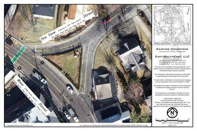
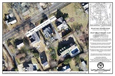
An aGIS map is available for this property. Click the image for the sales page or HERE for more information.

ASSESSING INFORMATION- LAST UPDATED 10-01-2018
Parcel ID: 9D-49-RR5
Assessors' Card
An aGIS map is available for this property. Click the image for the sales page or HERE for more information.
ASSESSING INFORMATION- LAST UPDATED 10-01-2018
Parcel ID: 9D-51-RR8
Assessors' Card

An aGIS map is available for this property. Click the image for the sales page or HERE for more information.
ASSESSING INFORMATION- LAST UPDATED 10-01-2018
Parcel ID: 9D-50-RR6
Assessors' Card
An aGIS map is available for this property. Click the image for the sales page or HERE for more information.
ASSESSING INFORMATION- LAST UPDATED 10-01-2018
Parcel ID: 9D-29A-RR7A
Assessors' Card
An aGIS map is available for this property. Click the image for the sales page or HERE for more information.
ASSESSING INFORMATION- LAST UPDATED 10-01-2018
Parcel ID: 9D-30-RR7
Assessors' Card
An aGIS map is available for this property. Click the image for the sales page or HERE for more information.

An aGIS map is available for this property. Click the image for the sales page or HERE for more information.
ASSESSING INFORMATION- LAST UPDATED 10-01-2018
Parcel ID: 15D-16B-X3
Assessors' Card
An aGIS map is available for this property. Click the image for the sales page or HERE for more information.
ASSESSING INFORMATION- LAST UPDATED 10-01-2018
Parcel ID: 15D-16A-X2
Assessors' Card

An aGIS map is available for this property. Click the image for the sales page or HERE for more information.
ASSESSING INFORMATION- LAST UPDATED 10-01-2018
Parcel ID: 15D-16-X1
Assessors' Card

An aGIS map is available for this property. Click the image for the sales page or HERE for more information.
ASSESSING INFORMATION- LAST UPDATED 10-01-2018
Parcel ID: 15E-4-14
Assessors' Card


An aGIS map is available for this property. Click the image for the sales page or HERE for more information.
ASSESSING INFORMATION- LAST UPDATED 10-01-2018
Parcel ID: 15E-85-1C
Assessors' Card

An aGIS map is available for this property. Click the image for the sales page or HERE for more information.
ASSESSING INFORMATION- LAST UPDATED 10-01-2018
Parcel ID: 15E-5-15
Assessors' Card
ASSESSING INFORMATION- LAST UPDATED 10-01-2018
Parcel ID: 15E-85A-2B
Assessors' Card

An aGIS map is available for this property. Click the image for the sales page or HERE for more information.
ASSESSING INFORMATION- LAST UPDATED 10-01-2018
Parcel ID: 15D-86-B1B
Assessors' Card

An aGIS map is available for this property. Click the image for the sales page or HERE for more information.
ASSESSING INFORMATION- LAST UPDATED 10-01-2018
Parcel ID: 15E-82-1B
Assessors' Card

An aGIS map is available for this property. Click the image for the sales page or HERE for more information.
ASSESSING INFORMATION- LAST UPDATED 10-01-2018
Parcel ID: 15E-6-16
Assessors' Card
ASSESSING INFORMATION- LAST UPDATED 10-01-2018
Parcel ID: 15E-80-1A
Assessors' Card

An aGIS map is available for this property. Click the image for the sales page or HERE for more information.
ASSESSING INFORMATION- LAST UPDATED 10-01-2018
Parcel ID: 15E-7-17
Assessors' Card
ASSESSING INFORMATION- LAST UPDATED 10-01-2018
Parcel ID: 15E-79-2C
Assessors' Card

An aGIS map is available for this property. Click the image for the sales page or HERE for more information.