
ASSESSING INFORMATION- LAST UPDATED 09-27-2018
Parcel ID: 16C-44-19
Assessors' Card
82 School St
ASSESSING INFORMATION- LAST UPDATED 09-27-2018
Parcel ID: 16C-43-17
Assessors' Card
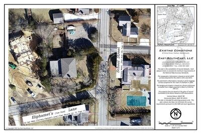
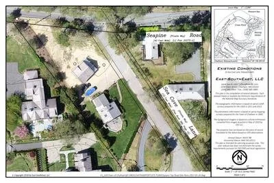
aGIS or accurate GIS is an existing conditions plan exceeding the National Map Accuracy Standards with portions meeting the Survey Standards of 250 CMR.
85 School St
ASSESSING INFORMATION- LAST UPDATED 09-27-2018
Parcel ID: 16C-16-40
Assessors' Card
94 School St
ASSESSING INFORMATION- LAST UPDATED 09-27-2018
Parcel ID: 16C-30-8
Assessors' Card

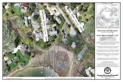
aGIS or accurate GIS is an existing conditions plan exceeding the National Map Accuracy Standards with portions meeting the Survey Standards of 250 CMR.
99 School St
ASSESSING INFORMATION- LAST UPDATED 09-27-2018
Parcel ID: 16C-17-42
Assessors' Card
104 School St
ASSESSING INFORMATION- LAST UPDATED 09-27-2018
Parcel ID: 16C-29-7A
Assessors' Card
107 School St
ASSESSING INFORMATION- LAST UPDATED 09-27-2018
Parcel ID: 16C-18-69A
Assessors' Card
110 School St
ASSESSING INFORMATION- LAST UPDATED 09-27-2018
Parcel ID: 16C-28-7B
Assessors' Card
117 School St
ASSESSING INFORMATION- LAST UPDATED 09-27-2018
Parcel ID: 16C-19-5
Assessors' Card
122 School St
ASSESSING INFORMATION- LAST UPDATED 09-27-2018
Parcel ID: 16C-27-2
Assessors' Card
7G-LAKE-VIEW Schoolhouse Pond Rd
14 Schoolhouse Pond Rd
ASSESSING INFORMATION- LAST UPDATED 09-27-2018
Parcel ID: 7G-5-M12
Assessors' Card
15 Schoolhouse Pond Rd
ASSESSING INFORMATION- LAST UPDATED 09-27-2018
Parcel ID: 7G-3-X5
Assessors' Card
23 Schoolhouse Pond Rd
ASSESSING INFORMATION- LAST UPDATED 09-27-2018
Parcel ID: 7G-3-X3
Assessors' Card
31 Schoolhouse Pond Rd
ASSESSING INFORMATION- LAST UPDATED 09-27-2018
Parcel ID: 7G-3-X4
Assessors' Card
34 Schoolhouse Pond Rd
ASSESSING INFORMATION- LAST UPDATED 09-27-2018
Parcel ID: 7G-3-X2
Assessors' Card
36 Schoolhouse Pond Rd


11K-CA-S6A Sea Cove
10 Sea Cove Ln
ASSESSING INFORMATION- LAST UPDATED 09-27-2018
Parcel ID: 10L-8A-S3
Assessors' Card
map is available for this property. Click the image for the sales page or HERE for more information.
30 Sea Cove Ln
ASSESSING INFORMATION- LAST UPDATED 09-27-2018
Parcel ID: 11K-16A-S4
Assessors' Card
map is available for this property. Click the image for the sales page or HERE for more information.