
ASSESSING INFORMATION- LAST UPDATED 09-27-2018
Parcel ID: 7G-7-M18
Assessors' Card
432 Sam Ryder Rd
ASSESSING INFORMATION- LAST UPDATED 09-27-2018
Parcel ID: 7G-3-X7
Assessors' Card
14 Samoset Ln
ASSESSING INFORMATION- LAST UPDATED 09-25-2018
Parcel ID: 4F-1E-RC25
Assessors' Card

An aGIS map is available for this property. Click the image for the sales page or HERE for more information.
15 Samoset Ln
ASSESSING INFORMATION- LAST UPDATED 09-25-2018
Parcel ID: 4F-1G-RC22
Assessors' Card

An aGIS map is available for this property. Click the image for the sales page or HERE for more information.
25 Samoset Ln
ASSESSING INFORMATION- LAST UPDATED 09-25-2018
Parcel ID: 4F-1H-RC23
Assessors' Card

An aGIS map is available for this property. Click the image for the sales page or HERE for more information.
26 Samoset Ln
ASSESSING INFORMATION- LAST UPDATED 09-25-2018
Parcel ID: 4F-1C-RC24
Assessors' Card

An aGIS map is available for this property. Click the image for the sales page or HERE for more information.
38 Sandy Shoes Ln
ASSESSING INFORMATION- LAST UPDATED 09-25-2018
Parcel ID: 16F-1-S2
Assessors' Card
64 Sandy Shoes Ln
ASSESSING INFORMATION- LAST UPDATED 09-25-2018
Parcel ID: 16F-3-S4
Assessors' Card
15A-9D-H14D Scallop Ter
15A-9E-H14E Scallop Ter
2 Scallop Ter
ASSESSING INFORMATION- LAST UPDATED 09-27-2018
Parcel ID: 16A-28A-H14I
Assessors' Card


An aGIS map is available for this property. Click the image for the sales page or HERE for more information.
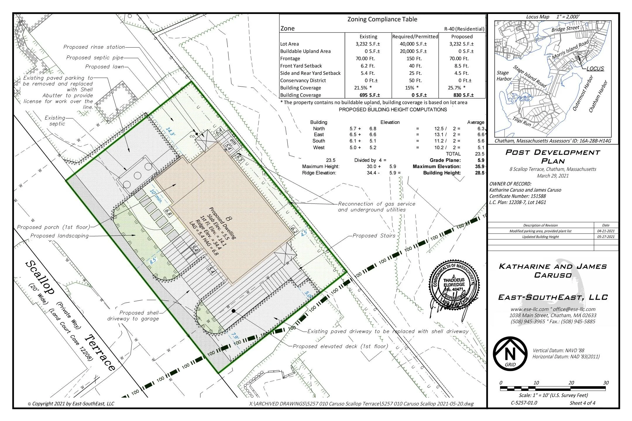
8 Scallop Ter
ASSESSING INFORMATION- LAST UPDATED 09-27-2018
Parcel ID: 16A-28B-H14G
Assessors' Card
Little Beach Analysis


An aGIS map is available for this property. Click the image for the sales page or HERE for more information.
9 Scallop Ter
ASSESSING INFORMATION- LAST UPDATED 09-27-2018
Parcel ID: 15A-9C-H14C
Assessors' Card

An aGIS map is available for this property. Click the image for the sales page or HERE for more information.
16 Scallop Ter
ASSESSING INFORMATION- LAST UPDATED 09-27-2018
Parcel ID: 16A-28C-H14F
Assessors' Card

An aGIS map is available for this property. Click the image for the sales page or HERE for more information.
17 Scallop Ter
ASSESSING INFORMATION- LAST UPDATED 09-27-2018
Parcel ID: 15A-9C-H14B
Assessors' Card
An aGIS map is available for this property. Click the image for the sales page or HERE for more information.

An aGIS map is available for this property. Click the image for the sales page or HERE for more information.
17J-0-C11 Scatteree Rd

An aGIS map is available for this property. Click the image for the sales page or HERE for more information.
16J-35-15 Scatteree Rd

An aGIS map is available for this property. Click the image for the sales page or HERE for more information.
16J-7A-WA1 Scatteree Rd
48 Scatteree Rd
ASSESSING INFORMATION- LAST UPDATED 09-27-2018
Parcel ID: 16J-7B-WA2
Assessors' Card

An aGIS map is available for this property. Click the image for the sales page or HERE for more information.
66 Scatteree Rd
ASSESSING INFORMATION- LAST UPDATED 09-27-2018
Parcel ID: 16J-7A-WA1
Assessors' Card

An aGIS map is available for this property. Click the image for the sales page or HERE for more information.