

ASSESSING INFORMATION- LAST UPDATED 09-27-2018
Parcel ID: 6E-19A-S3
Assessors' Card
36 Sam Ryder Rd

ASSESSING INFORMATION- LAST UPDATED 09-27-2018
Parcel ID: 6E-1C-R6
Assessors' Card
37 Sam Ryder Rd

ASSESSING INFORMATION- LAST UPDATED 09-27-2018
Parcel ID: 6E-20-10
Assessors' Card
40 Sam Ryder Rd

ASSESSING INFORMATION- LAST UPDATED 09-27-2018
Parcel ID: 6E-1D-R7
Assessors' Card
94 Sam Ryder Rd
ASSESSING INFORMATION- LAST UPDATED 09-27-2018
Parcel ID: 6F-32E-R12
Assessors' Card

97 Sam Ryder Rd
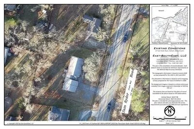
2014 aerial imagery, 2011 & 2013 aerial LiDAR, base plani from 2000 with some revisions. Property line compiled with some monumentation to SPCS NAD 83, 2011
115 Sam Ryder Rd
ASSESSING INFORMATION- LAST UPDATED 09-27-2018
Parcel ID: 6F-4-M13
Assessors' Card
147 Sam Ryder Rd
ASSESSING INFORMATION- LAST UPDATED 09-27-2018
Parcel ID: 6F-20A-M15
Assessors' Card

An aGIS map is available for this property. Click the image for the sales page or HERE for more information.
157 Sam Ryder Rd
ASSESSING INFORMATION- LAST UPDATED 09-27-2018
Parcel ID: 6F-21-M16
Assessors' Card

An aGIS map is available for this property. Click the image for the sales page or HERE for more information.
175 Sam Ryder Rd
ASSESSING INFORMATION- LAST UPDATED 09-27-2018
Parcel ID: 6F-23-M29
Assessors' Card

An aGIS map is available for this property. Click the image for the sales page or HERE for more information.
187 Sam Ryder Rd
ASSESSING INFORMATION- LAST UPDATED 09-27-2018
Parcel ID: 6F-24-M30
Assessors' Card

An aGIS map is available for this property. Click the image for the sales page or HERE for more information.

An aGIS map is available for this property. Click the image for the sales page or HERE for more information.
196 Sam Ryder Rd
197 Sam Ryder Rd
ASSESSING INFORMATION- LAST UPDATED 09-27-2018
Parcel ID: 6F-25-M31
Assessors' Card


An aGIS map is available for this property. Click the image for the sales page or HERE for more information.
207 Sam Ryder Rd
ASSESSING INFORMATION- LAST UPDATED 09-27-2018
Parcel ID: 6F-26-M32
Assessors' Card

An aGIS map is available for this property. Click the image for the sales page or HERE for more information.
217 Sam Ryder Rd
ASSESSING INFORMATION- LAST UPDATED 09-27-2018
Parcel ID: 6F-27-M33
Assessors' Card

An aGIS map is available for this property. Click the image for the sales page or HERE for more information.
224 Sam Ryder Rd
ASSESSING INFORMATION- LAST UPDATED 09-27-2018
Parcel ID: 7F-4-H3
Assessors' Card
225 Sam Ryder Rd
ASSESSING INFORMATION- LAST UPDATED 09-27-2018
Parcel ID: 6F-28-M34
Assessors' Card

An aGIS map is available for this property. Click the image for the sales page or HERE for more information.
237 Sam Ryder Rd
ASSESSING INFORMATION- LAST UPDATED 09-27-2018
Parcel ID: 6G-15-M35
Assessors' Card
An aGIS map is available for this property. Click the image for the sales page or HERE for more information.
245 Sam Ryder Rd
ASSESSING INFORMATION- LAST UPDATED 09-27-2018
Parcel ID: 6G-12-M36
Assessors' Card

An aGIS map is available for this property. Click the image for the sales page or HERE for more information.
258 Sam Ryder Rd
ASSESSING INFORMATION- LAST UPDATED 09-27-2018
Parcel ID: 7G-61-M41
Assessors' Card