ASSESSING INFORMATION- LAST UPDATED 09-25-2018
Parcel ID: 13J-13-R10
Assessors' Card
An aGIS map is available for this property. Click the image for the sales page or HERE for more information.

ASSESSING INFORMATION- LAST UPDATED 09-25-2018
Parcel ID: 13J-13-R10
Assessors' Card

An aGIS map is available for this property. Click the image for the sales page or HERE for more information.
ASSESSING INFORMATION- LAST UPDATED 09-25-2018
Parcel ID: 13J-16-R7
Assessors' Card

An aGIS map is available for this property. Click the image for the sales page or HERE for more information.
ASSESSING INFORMATION- LAST UPDATED 09-25-2018
Parcel ID: 13J-14-R9
Assessors' Card
RESEARCH
3806-110 OOC 1983 Dock
4371-183 COC 1984 Dock
9145-40 Dock Interim Approval
An aGIS map is available for this property. Click the image for the sales page or HERE for more information.
ASSESSING INFORMATION- LAST UPDATED 09-25-2018
Parcel ID: 13J-15-R8
Assessors' Card


An aGIS map is available for this property. Click the image for the sales page or HERE for more information.

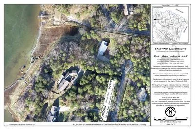
An aGIS map is available for this property. Click the image for the sales page or HERE for more information.

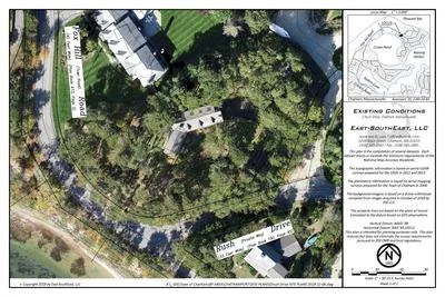
An aGIS map is available for this property. Click the image for the sales page or HERE for more information.

An aGIS map is available for this property. Click the image for the sales page or HERE for more information.

An aGIS map is available for this property. Click the image for the sales page or HERE for more information.

An aGIS map is available for this property. Click the image for the sales page or HERE for more information.

An aGIS map is available for this property. Click the image for the sales page or HERE for more information.

An aGIS map is available for this property. Click the image for the sales page or HERE for more information.

An aGIS map is available for this property. Click the image for the sales page or HERE for more information.

An aGIS map is available for this property. Click the image for the sales page or HERE for more information.

An aGIS map is available for this property. Click the image for the sales page or HERE for more information.

An aGIS map is available for this property. Click the image for the sales page or HERE for more information.
ASSESSING INFORMATION- LAST UPDATED 09-25-2018
Parcel ID: 12M-10-B1
Assessors' Card
An aGIS map is available for this property. Click the image for the sales page or HERE for more information.
ASSESSING INFORMATION- LAST UPDATED 09-25-2018
Parcel ID: 12M-11-B3
Assessors' Card

An aGIS map is available for this property. Click the image for the sales page or HERE for more information.
ASSESSING INFORMATION- LAST UPDATED 09-25-2018
Parcel ID: 12M-12-B4
Assessors' Card

An aGIS map is available for this property. Click the image for the sales page or HERE for more information.
