ASSESSING INFORMATION- LAST UPDATED 06-011-2018
Parcel ID: 3C-18-43
Assessors' Card
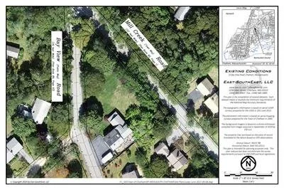
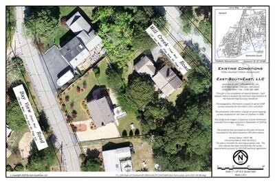
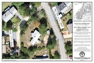
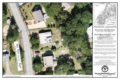
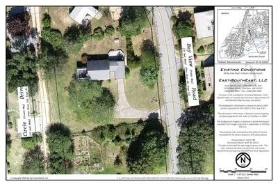
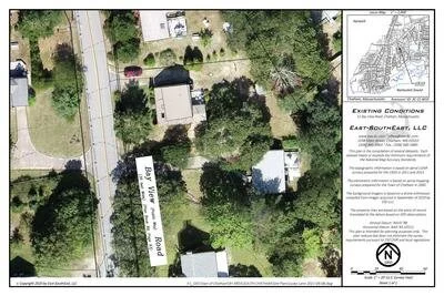
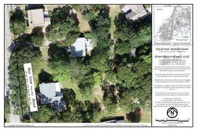
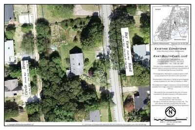
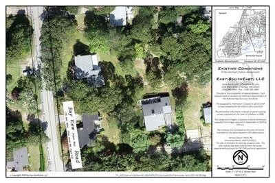
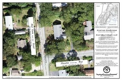
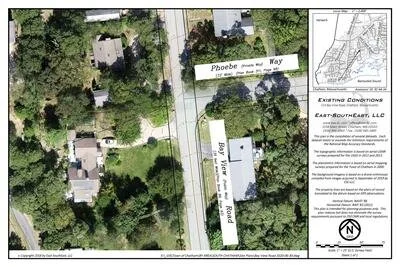
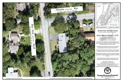
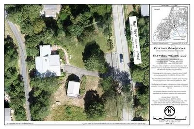
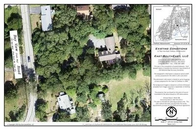
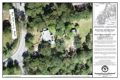
aGIS or accurate GIS is an existing conditions plan exceeding the National Map Accuracy Standards with portions meeting the Survey Standards of 250 CMR.

ASSESSING INFORMATION- LAST UPDATED 06-011-2018
Parcel ID: 3C-18-43
Assessors' Card
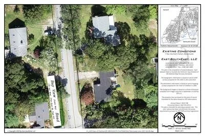
aGIS or accurate GIS is an existing conditions plan exceeding the National Map Accuracy Standards with portions meeting the Survey Standards of 250 CMR.
ASSESSING INFORMATION- LAST UPDATED 06-011-2018
Parcel ID: 3C-19-M8
Assessors' Card
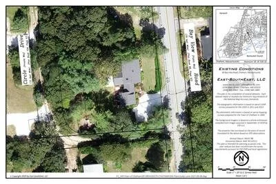
aGIS or accurate GIS is an existing conditions plan exceeding the National Map Accuracy Standards with portions meeting the Survey Standards of 250 CMR.
ASSESSING INFORMATION- LAST UPDATED 06-011-2018
Parcel ID: 3C-53A-E3
Assessors' Card
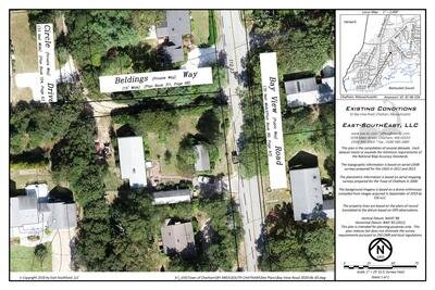
aGIS or accurate GIS is an existing conditions plan exceeding the National Map Accuracy Standards with portions meeting the Survey Standards of 250 CMR.
ASSESSING INFORMATION- LAST UPDATED 06-011-2018
Parcel ID: 3C-20-M9
Assessors' Card
aGIS or accurate GIS is an existing conditions plan exceeding the National Map Accuracy Standards with portions meeting the Survey Standards of 250 CMR.
ASSESSING INFORMATION- LAST UPDATED 06-011-2018
Parcel ID: 3C-53B-E5
Assessors' Card
aGIS or accurate GIS is an existing conditions plan exceeding the National Map Accuracy Standards with portions meeting the Survey Standards of 250 CMR.
ASSESSING INFORMATION- LAST UPDATED 06-011-2018
Parcel ID: 3C-21-M10
Assessors' Card
aGIS or accurate GIS is an existing conditions plan exceeding the National Map Accuracy Standards with portions meeting the Survey Standards of 250 CMR.
ASSESSING INFORMATION- LAST UPDATED 06-011-2018
Parcel ID: 3C-22-M11
Assessors' Card
aGIS or accurate GIS is an existing conditions plan exceeding the National Map Accuracy Standards with portions meeting the Survey Standards of 250 CMR.
ASSESSING INFORMATION- LAST UPDATED 06-011-2018
Parcel ID: 3C-53C-30A
Assessors' Card
aGIS or accurate GIS is an existing conditions plan exceeding the National Map Accuracy Standards with portions meeting the Survey Standards of 250 CMR.
ASSESSING INFORMATION- LAST UPDATED 06-011-2018
Parcel ID: 3C-23-B1
Assessors' Card
aGIS or accurate GIS is an existing conditions plan exceeding the National Map Accuracy Standards with portions meeting the Survey Standards of 250 CMR.
ASSESSING INFORMATION- LAST UPDATED 06-011-2018
Parcel ID: 3C-24-40A
Assessors' Card
aGIS or accurate GIS is an existing conditions plan exceeding the National Map Accuracy Standards with portions meeting the Survey Standards of 250 CMR.
ASSESSING INFORMATION- LAST UPDATED 06-011-2018
Parcel ID: 3C-53E-32
Assessors' Card
aGIS or accurate GIS is an existing conditions plan exceeding the National Map Accuracy Standards with portions meeting the Survey Standards of 250 CMR.
ASSESSING INFORMATION- LAST UPDATED 06-011-2018
Parcel ID: 3C-46-33A
Assessors' Card
An aGIS map is available for this property. Click the image for the sales page or HERE for more information.
ASSESSING INFORMATION- LAST UPDATED 06-011-2018
Parcel ID: 3C-39A-P1
Assessors' Card
An aGIS map is available for this property. Click the image for the sales page or HERE for more information.
ASSESSING INFORMATION- LAST UPDATED 06-011-2018
Parcel ID: 3C-45-33
Assessors' Card

An aGIS map is available for this property. Click the image for the sales page or HERE for more information.
ASSESSING INFORMATION- LAST UPDATED 06-011-2018
Parcel ID: 3C-44-34
Assessors' Card
An aGIS map is available for this property. Click the image for the sales page or HERE for more information.
ASSESSING INFORMATION- LAST UPDATED 06-011-2018
Parcel ID: 3C-39-P9
Assessors' Card
An aGIS map is available for this property. Click the image for the sales page or HERE for more information.
ASSESSING INFORMATION- LAST UPDATED 06-011-2018
Parcel ID: 3C-39F-P9
Assessors' Card
aGIS or accurate GIS is an existing conditions plan exceeding the National Map Accuracy Standards with portions meeting the Survey Standards of 250 CMR.
ASSESSING INFORMATION- LAST UPDATED 06-011-2018
Parcel ID: 3C-41-38
Assessors' Card
aGIS or accurate GIS is an existing conditions plan exceeding the National Map Accuracy Standards with portions meeting the Survey Standards of 250 CMR.
ASSESSING INFORMATION- LAST UPDATED 06-011-2018
Parcel ID: 3C-42-37
Assessors' Card
aGIS or accurate GIS is an existing conditions plan exceeding the National Map Accuracy Standards with portions meeting the Survey Standards of 250 CMR.