
ASSESSING INFORMATION- LAST UPDATED 10-16-2018
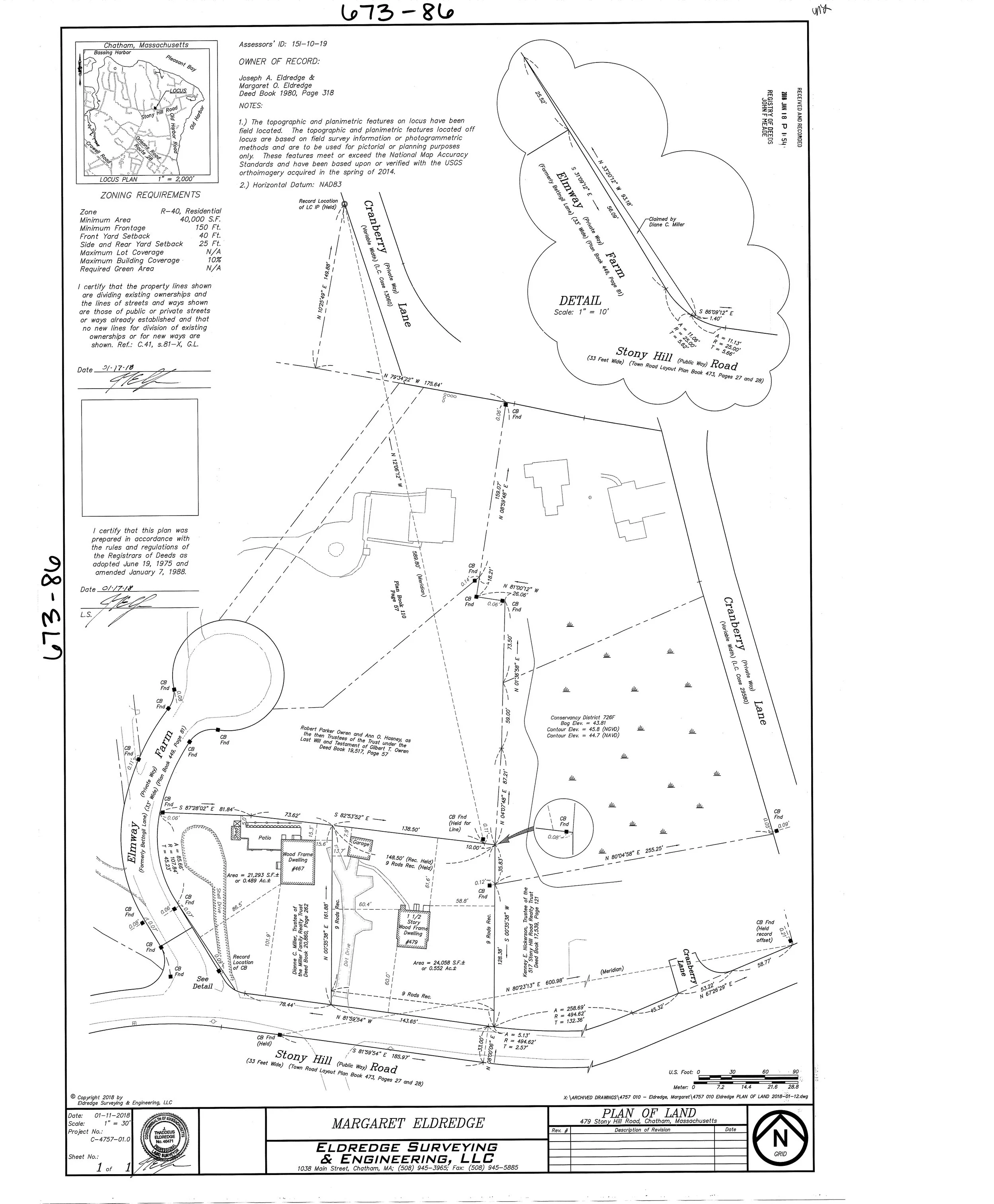
Parcel ID: 15I-10-19
Assessors' Card

This 2008 sketch was based on the more recent deeds of the area and depicts the overlap caused by holding the plans of record to the east and to the west. We prepared this for the owner of 467 Stony Hill Road, Dianne Campbell. We offered Mrs. Campbell two choices: either have the research performed to determine how these boundaries fit together or work with the neighbor, Mrs. Eldredge on a boundary agreement. She chose the latter but unfortunately the two neighbors could not reach an agreement. We did suggest that based on the use, the boundary was likely somewhere between the house at 467 and the detached garage at 479.
Mrs. Eldredge approached us in 2017 with the desire to sell her house. In order to do so, she needed the common boundary to be resolved, so the research was performed. The conclusion of the research is simple: 479 Stony Hill Road was divided from Salathiel Nickerson’s property in 1826 and was the first division of land from Salathiel Nickerson in the area. In 1869 the parent parcel for 467 Stony Hill Road was conveyed and in 1915, the easterly portion of 467 Stony Hill Road was conveyed into The Old Harbor Guild.
479 Stony Hill Road has the senior right and is entitled to 9 rods by 9 rods as defined in 1826.
This leaves the question of the starting point. Are the boundaries to the east and west correct, or do the original bounds of the subject properties overlap the descriptions of the current properties?
To the east is a property that was formerly cranberry bog. In 1941, 479 Stony Hill Road was conveyed from Benjamin Baker through Patia Crowell to Benjamin and Myra Baker. It described 479 as by the Cranberry Bog and Land of Frederick W. Baker. Below is a sketch of including the 1938 USGS aerial images that comports with this description as there is bog and land immediately east of the subject property.

To the west is Elmway Farm Road. The property was surveyed in the 1950’s and there was some flaw in the boundary that required remedy by the surveyors.


It is possible that the deficiency in 467 Stony Hill Road was in fact to the west. Given the locations of the uses, the historic location of the bog and the boundary agreement to the west, the opinion of the location of the common boundary line is as depicted on the recorded plan at the top of the webpage.